Historic Maps
Pre-human vs
Current Wetlands
Historic Maps
Whakarongo ki te Repo
Feeling the Life Rhythm of Wetlands
The three maps on this page provide insight into place names and locations from a time before large-scale displacement of Māori. As the surveyors were interacting with Māori in these locations, the place names used are likely to be relatively accurate but are subject to misspellings, miscommunication, or rewording by the surveyors. Information about how the historic maps were aligned with present day maps is provided after the maps along with more information about the surveyors themselves.
The maps on this page are:
- 1859 Igglesden and Knowles map covering land between Huangarua River and Otaraia Pā (Source: AAFV 997 W29 R22824240, Archives New Zealand)
- 1855 William Mein Smith map of Taranganui and Palliser Bay (Source: AFIH 22381 W5692 RP 709d R22549464, Archives New Zealand)
- 1855 William Mein Smith map of the Middle of the Wairarapa (Source: AFIH 22381 W5692 RP 710f R22549370, Archives New Zealand)
Click and drag the swipe controller on these maps (left and right) to compare present day maps of Wairarapa Moana to the historic maps. You can also zoom in to different locations using the controls on the left.
The three historic maps were sourced from Archives New Zealand and georeferenced by Jason Hansen in 2020 for his Master of Geographic Information Science (MGIS) thesis (entitled ‘A 19th Century Ngāti Kahungunu Basemap for South Wairarapa’) using current landscape features and entries from the surveyor fieldbooks. Jason completed the work in collaboration with Haami Te Whaiti and Foss Leach and was supervised by Mairéad de Róiste and Polly Stupples from Te Herenga Waka Victoria University of Wellington.
Georeferencing
Georeferencing involves aligning two sets of geographic data to each other. In this case, the aim was to overlay the historic maps on a modern map, using locations found in both data sets to link the two maps together (as accurately as possible). For this project, historic maps of Wairarapa were georeferenced against current satellite photographs of the area. Georeferencing the historic maps required stretching, turning, and scaling the scanned image to fit with the current online map.
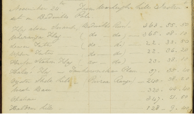
The georeferencing of the maps above was conducted by Jason Hansen. Jason used historic survey notebooks (LINZ Field Book ID WN_0109 & LINZ Field Book ID WN_0176) to locate 10 trig points that existed in the historic maps, still exist in the current landscape and are visible on current satellite photographs. Trig points are fixed locations used in surveying and mapping that can often be found at the tops of peaks and other important geographical locations. The trig points can consist of any size marker, from a simple round marker up to small towers.

A sample entry from William Mein Smith’s fieldbook from 1857 (WN_0109-0049, Archives New Zealand).
The Map Makers
Charles Moore Igglesden, 1832-1920, was born in Bombay, India and came to Wellington in 1856. He spent 37 years in the NZ Survey Department. He spent 3 years as Town Surveyor in Lyttleton and was the first official who walked through the Moorhouse Tunnel that links Lyttelton to Christchurch (now known as the Lyttleton Rail Tunnel). He was the architect of the old Custom House and Post Office, Wellington in addition to other public and private buildings. He eventually obtained the post of District Grand Secretary for the North Island. He was also an artist. (https://paperspast.natlib.govt.nz/newspapers/EP19200417.2.71)
Francis William Knowles, 1835-1887, arrived in Aotearoa New Zealand with his parents in 1841 aboard the ‘Oriental’, and attended St John’s College in Tamaki, Auckland. He worked as a surveyor in the southern part of the North Island before the Department of Lands and Survey was formed. In July of 1859 he worked with C.M. Igglesden to create the 1859 map. (https://natlib.govt.nz/records/22464052)
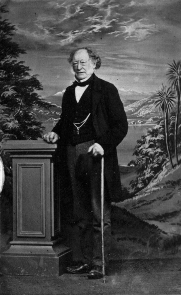
William Mein Smith 1799-1869, arrived at Port Nicholson (Wellington) in late 1839 onboard the ‘Cuba’. He was contracted by the New Zealand Company for a three-year term as their first surveyor general. Starting in January 1840, he laid out two settlements, Petone and Thorndon. Later in September 1842, he embarked on a mission to chart harbours along the east coast of the South Island, and reached Stewart Island and the Chatham Islands. A keen artist, he created many sketches and watercolours. He also enjoyed gardening, and introduced bamboo to Wellington. He served as the captain of the Thorndon militia in 1845. In 1845, Smith and his family moved to Huangarua in the Wairarapa, between Greytown and Martinborough, where he became a runholder. By 1858, they ran 20,000 sheep at Huangarua on over 20,000 acres of land. From 1853 to 1857, Smith was the government district surveyor in Wairarapa, conducting surveys for Crown purchases made by Donald McLean, and designating Māori reserves. In 1854, he partly mapped Wairarapa, including the Wharekaka Plains. He extended his survey work to the east, completing a coastal survey to Castle Point, as well as the triangulation of the Taratahi. During his trigonometrical survey, he defined the boundaries of Masterton and Greytown. In 1856, Smith laid out the town of Featherston. From 1851 to 1853, Smith served as a member of the Legislative Council and represented Wairarapa on the Wellington Provincial Council from 1858 to 1865. For many years he was the only resident magistrate in Wairarapa. Aside from his surveying duties, Smith’s reports on his exploratory travels and surveys are valuable for their documentation of colonial conditions. He documented geographical features as well as human behaviour, such as the novel techniques used by the Manawatu Māori for dressing flax.
(https://teara.govt.nz/en/biographies/1s16/smith-william-mein)
Image of William Mein Smith, circa 1868.
Image source: Richards, Edward Smallwood, 1834-1917 (Photographer) : William Mein Smith. Mantell, Walter Baldock Durrant:Family photograph albums. Ref: PA1-o-326-41. Alexander Turnbull Library, Wellington, New Zealand. /records/22903894


